__________________________________________
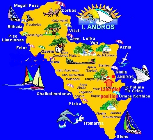
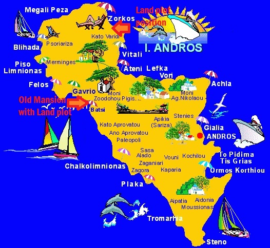
Short description of property : Greater Land plot on slopes opposite to Hora town of Andros island_FK-331
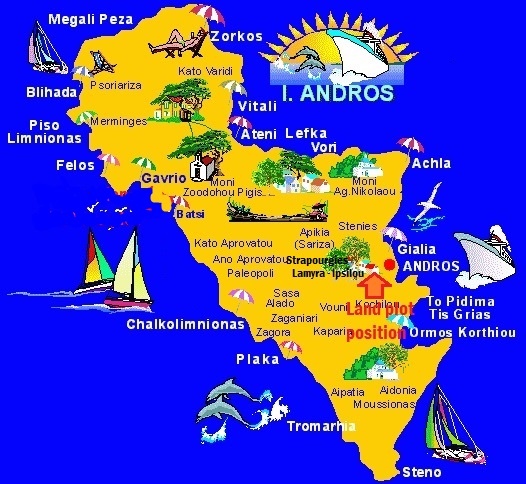
Map of general area of property :
|
LAND PLOT (specifications): |
|
|
Land Plot surface (sq.m.) |
10650 |
|
Orientation |
Eastern side of ANDROS island |
|
Position referring to village or town (distance) |
800 m |
|
Proximity to coastline |
400 m |
|
Proximity to Port of Arrival |
35 km |
|
Networks in distance |
running in parallel |
|
Included buildings (sq.m.) |
|
|
Building total Ability (Permit / sq.m.)) |
400 – 22000 |
|
Road of approach |
main road |
|
Water supply |
Municipal supply network + individual well |
|
Other special specifications:
|
fairly sloppy with step-like planes and panoramic view – private road – 600m. from Heli-port |
Other special details – Further description :
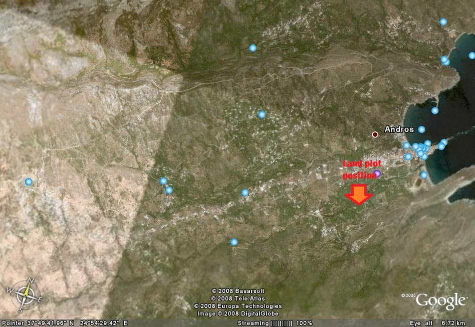
Greater Land-plot (10650 sq.m. / 2,66 acres) on the sloppy planes opposite to the peninsula where the little town of HORA is positioned. It is formed in climax-scheme of the land against the slop, and is also overlooking to the beach of Paraporti and the little river flowing through the little valley just below , near also to the village of LIVADIA , and including the chapelette of Agios Ioannis (St. John).
ASK FOR OUR ARCHITECT PLANNING and TECHNICAL ADVISORY ON DIFFERENT POSSIBLE DEVELOPMENT CHOICES
Final Price of Sale : 450.000 Eu.


———————————————————————
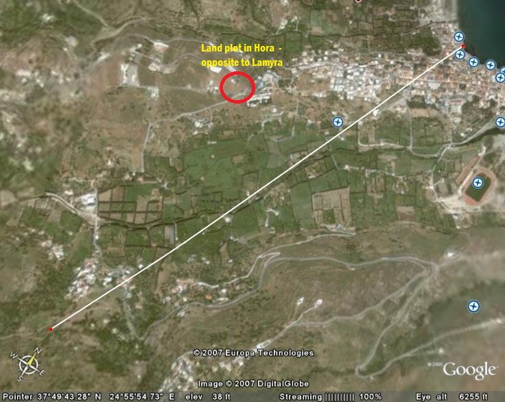
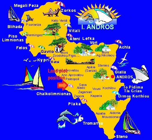
Short description of property : Greater Land plot on slopes opposite to Hora town of Andros island – in Lamyra valley_FK-332
Map of general area of property :
|
LAND PLOT (specifications): |
|
|
Land Plot surface (sq.m.) |
25490 |
|
Orientation |
Eastern side of ANDROS island |
|
Position referring to village or town (distance) |
400 m |
|
Proximity to coastline |
1000 m |
|
Proximity to Port of Arrival |
35 km |
|
Networks in distance |
running in parallel |
|
Included buildings (sq.m.) |
4 stone-built farm-use warehouses |
|
Building total Ability (Permit / sq.m.)) |
400 – 25000 |
|
Road of approach |
gravel road |
|
Water supply |
Municipal supply network + individual well |
|
Other special specifications:
|
fairly sloppy with step-like planes and panoramic view – private road – 1200m. from Heli-port |
Other special details – Further description :
Greater Land property (25490 sq.m. / 6,37 acres) on the sloppy planes of Kato Lamyra, just on the back-view of HORA town , very near to it and the beaches aside it. It also contains a stone-built pigeon-tower and 3 other older stone-built little buildings used as storage and farm-items . It has its own water well with the old iron-made mechanical pump in use. Its surface is schemed in the traditional/ local way or “staircase levels” to provide wide planes for plantation without any problem.
ASK FOR OUR ARCHITECT PLANNING and TECHNICAL ADVISORY ON DIFFERENT POSSIBLE DEVELOPMENT CHOICES
Final Price of Sale : 500.000 Eu.
Photos of the Land plot and its mapping position :


———————————————————————
Short description of property : Land plot beside Hora town of Andros island – over Neiboreio beach_FK-337
Map of general area of property :
|
LAND PLOT (specifications): |
|
|
Land Plot surface (sq.m.) |
12289 |
|
Orientation |
Eastern side of ANDROS island |
|
Position referring to village or town (distance) |
1400 m (from Lamyra) / 200 m (to Hora town) |
|
Proximity to coastline |
300 m |
|
Proximity to Port of Arrival |
35 km |
|
Networks in distance |
in parallel |
|
Included buildings (sq.m.) |
|
|
Building total Ability (Permit / sq.m.) |
400 – 24000 |
|
Road of approach |
main road |
|
Water supply |
Municipal supply (option) |
|
Other special specifications:
|
fairly sloppy with step-like planes and panoramic view & approach to beach below – 3600m. from Heli-port |
Other special details – Further description :
Unique great land plot (12.289 sq.m.) just on the inclined slop of land outside the peripheral outline of HORA little town, opposite to Hotel “PARADISE” and under the main road of the island. Due to its massive surface and its inclination it is ideal for a building complex of multi storreys , for every residential – tourism or other commercial use (like Logistics’ Warehouse) in the total of it , or divided to 3 different smaller land-plots , it can also be legally permitted to build 3 different Vacation Homes with a lot of surrounding land for gardens, and even include spacious swimming pools.
ASK OUR ARCHITECT FOR HIS PLANNING PROPOSALS OF YOUR OWN CHOICE OF USE !!
Final Price of Sale : 460.000 Eu.
Photos of the Land plot and its mapping position :


———————————————————————
Short description of property : Greater Land plot beside Strapourgies village – over Hora_FK-338
Map of general area of property :
|
LAND PLOT (specifications): |
|
|
Land Plot surface (sq.m.) |
17500 |
|
Orientation |
Eastern side of ANDROS island |
|
Position referring to village or town (distance) |
500 m (from Strapourgies) / 4000 m (from Hora town) |
|
Proximity to coastline |
2000 m |
|
Proximity to Port of Arrival |
35 km |
|
Networks in distance |
in parallel |
|
Included buildings (sq.m.) |
|
|
Building total Ability (Permit / sq.m.) |
400 – 35000 |
|
Road of approach |
main road |
|
Water supply |
Municipal supply (option) |
|
Other special specifications: |
fairly sloppy with step-like planes and panoramic view – 3600m. from Heli-port |
Other special details – Further description :
Greater Land property (17500 sq.m. / 4,41 acres) near to STRAPOURGIES village and overlooking to the whole valley between MESSARIA village and the town of HORA, and all the Eastern coastline of Andros island. It is for Sale either in whole or divided in smaller land-plots – 5000 sq.m. (2 X) and 7500 sq.m. (1 X).
ASK OUR ARCHITECT FOR HIS PLANNING PROPOSALS OF YOUR OWN CHOICE OF USE !!
Final Price of Sale : 300.000 Eu. (whole plot) – 110.000 – 120.000 Eu (each partial plot)
Photos of the Land plot and its mapping position :
———————————————————————
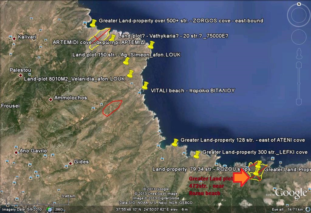
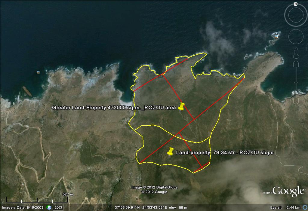
Short description of property : Greater Land plot near to Platanistos cape_FK-340
Map of general area of property :
|
LAND PLOT (specifications): |
|
|
Land Plot surface (sq.m.) |
472000 |
|
Orientation |
Eastern side of ANDROS island |
|
Position referring to village or town (distance) |
3 km (from Vourkoti) / 25 km (from Hora) |
|
Proximity to coastline |
inclusive with coast (between 2 coves) |
|
Proximity to Port of Arrival |
25 km |
|
Networks in distance |
|
|
Included buildings (sq.m.) |
|
|
Building total Ability (Permit / sq.m.) |
400 – 600000 |
|
Road of approach |
gravel and pavement road – 2 km from main road |
|
Water supply |
|
|
Other special specifications: |
fairly sloppy with step-like planes and panoramic view – 27 km. from Heli-port |
Other special details – Further description :
Greater Land property (472000 sq.m. / 118 acres) , spread in whole on 2 cliffs and its sloppy planes and the valley between them, over Rozou little beach, next to the Achla cove and beach and the cape of Platanistos. Nearest village is VOURKOTI and ARNI, but the town of HORA is at a distance of 25 km and BATSI at 28 km.
Sale price : negotiable but also Interested for a partnership scheme on some Development Project.
ASK OUR ARCHITECT FOR HIS PLANNING PROPOSALS OF YOUR OWN CHOICE OF USE !!
Final Price of Sale : 2.500.000 Eu
Photos of the Land plot and its mapping position :
———————————————————————
Short description of property : Greater Land plot near to Lefka cove_FK-343
Map of general area of property :
|
LAND PLOT (specifications): |
|
|
Land Plot surface (sq.m.) |
800000 |
|
Orientation |
Eastern side of ANDROS island |
|
Position referring to village or town (distance) |
12 km (Vourkoti) / 30 km (Hora) |
|
Proximity to coastline |
inclusive with coast |
|
Proximity to Port of Arrival |
20 km |
|
Networks in distance |
|
|
Included buildings (sq.m.) |
|
|
Building total Ability (Permit / sq.m.) |
400 – 800000 |
|
Road of approach |
gravel and pavement road – 3,5 km from main road |
|
Water supply |
|
|
Other special specifications: |
fairly sloppy with step-like planes and panoramic view – 33 km. from Heli-port |
Other special details – Further description :
Greater Land property (800000 – 850000 sq.m. / 200-212,5 acres) , whole on cliffs and its sloppy planes beside the valley between them, between Zorgos cove and beach and Vitali bay, over Lefka cove and beach (inclusive coastline at 200-1600 m). Nearest village is VOURKOTI and ARNI, but the town of HORA is at a distance of 30 kms and GAVRION Port at 16 kms.
ASK OUR ARCHITECT FOR HIS PLANNING PROPOSALS OF YOUR OWN CHOICE OF USE !!
Final Price of Sale : 3.000.000 Eu
Photos of the Land plot and its mapping position :


——————————————————————–
Short description of property : Greater Land plot over Ateni cove and beaches_FK-342
Map of general area of property :

|
LAND PLOT (specifications): |
|
|
Land Plot surface (sq.m.) |
128000 |
|
Orientation |
Eastern side of ANDROS island |
|
Position referring to village or town (distance) |
3 km (from Katakoilos) / 30 km (to Hora) |
|
Proximity to coastline |
inclusive with coast |
|
Proximity to Port of Arrival |
18 km |
|
Networks in distance |
|
|
Included buildings (sq.m.) |
|
|
Building total Ability (Permit / sq.m.) |
400 – 120000 |
|
Road of approach |
gravel and pavement road – 2 km from main road |
|
Water supply |
|
|
Other special specifications: |
fairly sloppy with step-like planes and panoramic view – 38 km. from Heli-port |
Other special details – Further description :
Greater Land plot 128000 sq.m. along the coastline between the cove and beach of Ateni and the next cove , on the Eastern side of ANDROS island. Including the coastline across its borders with the sea and a well established borderline with inner land, near to the villages of Remmata , Katakoilos and Arni, forming a wide valley that ends to the dual beaches of Ateni. Full with Land Plan and official documentation (Forest Authority etc.) is ideal for immediate Master Plan for a Development Project in Residential and Vacation Villas fields. The Port of Gavrion is just 18 km far and HORA town at 30 km., while the most touristic-famous village (with a Marina) – BATSI is at 7-8 km distance.
ASK OUR ARCHITECT FOR HIS PLANNING PROPOSALS OF YOUR OWN CHOICE OF USE !!
Final Price of Sale : 550.000 Eu
Photos of the Land plot and its mapping position :


——————————————————————–
Short description of property : Greater Land plot near Chalkolimionas bay and beach_FK-346
Map of general area of property :
|
LAND PLOT (specifications): |
|
|
Land Plot surface (sq.m.) |
26500 |
|
Orientation |
Western side of ANDROS island |
|
Position referring to village or town (distance) |
5 km (Pitrofos village) / 15 km (Hora) |
|
Proximity to coastline |
300m from coast |
|
Proximity to Port of Arrival |
18 km (Gavrion Port) |
|
Networks in distance |
2 km |
|
Included buildings (sq.m.) |
|
|
Building total Ability (Permit / sq.m.) |
400 – 52000 |
|
Road of approach |
gravel and pavement road – 1,5 km from main road |
|
Water supply |
|
|
Other special specifications: |
fairly sloppy with step-like planes and panoramic view – 18 km. from Heli-port |
Other special details – Further description :
Greater Land Property very near to seaside (26500 sq.m.), on well slopped planes formatted in the traditional step-like levelize of soil (to make harvest work easier). It is ideally positioned on the middle area on the Westen side of Andros island – just 300m. from the coastline and 450m. from one of the most famous beach on the whole island – CHALKOLIMIONAS bay and beach – gathering crowds of visitors and swimming peopla , also featuring a beach-bar with 24hr. music cover. Overlooking the northwestern part of Aegean Sea and the sea-routes of the ferry-ships going to the nearest CYCLADES (Tinos – Mykonos – Paros – Naxos) and the opposite rocky island of GYAROS (a Monumental place for modern Greek History of Democracy), it also is favoured to have one of the most amazing overall View at Sundown (equal to the world famous of OIA at Santorini island), while another beach that is ideal for more quiet and privacy is in very short distance – APOTHIKES . All those qualities , together with the very fair proximity by car using the main road net of the island, ensure that it is ideal for every use : building a “palace-like” villa or more – a full Vacation Residential Project – a multi-purpose Hotel & Tourism Amenity Project Plan – even a Fun Park combined with Sea Park (number of swimming pools with games and sports).
ASK OUR ARCHITECT FOR HIS PLANNING PROPOSALS OF YOUR OWN CHOICE OF USE !!
Final Price of Sale : 550.000 Eu
Photos of the Land plot and its mapping position :


